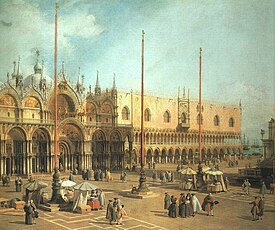
Piazza San Marco

St Mark's Square, often known in English by its Italian name Piazza San Marco, is the town square of Venice, Italy.
The Piazza is the only urban space big enough to be called a piazza in Venice: the rest are campi. Whether it was actually Napoleon, or the French Romantic poet Alfred de Musset who called it the "drawing-room of Europe", it is the only great urban space in a European city where the sound is of human voices talking.
At right angles to the Piazza is the Piazzetta, with the Doge's Palace. There are three ships' masts at the water front, and have been since at least 1480. The banner of St Mark is flown from them on feast days.
St Mark's Square is extremely popular with tourists, photographers and pigeons.
History
The Square originated in the ninth century as a small area in front of the original St Mark's Basilica. It was enlarged to its present size and shape in 1177, when the Rio Batario, which had bounded it to the west, and a dock, which had isolated the Doge's Palace from the square, were filled in. The rearrangement was for the meeting of Pope Alexander III and the Emperor Frederick Barbarossa.
The Square has always been seen as the centre of Venice. It was the location of all the important offices of the Venetian state, and has been the seat of the bishopric since the nineteenth century. It was also the focus for many of Venice's festivals.
Buildings
The Piazza is dominated by the Basilica, the Doge's Palace and (illustration, left below), and by the Basilica's campanile, which stands apart from it.
The buildings around the Square, anti-clockwise from the Grand Canal, are the Doge's Palace, St Mark's Basilica, St Mark's Clocktower, the Procuratie Vecchie, the Napoleonic Wing of the Procuraties, the Procuratie Nuove, St Mark's Campanile and Logetta and the Biblioteca Marciana. Most of the ground floor of the Procuraties is occupied by cafes, including the Caffè Florian and Gran Caffè Quadri. The Correr Museum and the Museum of Archaeology are located in some of the buildings of the Square. The Venetian Mint lies beyond the Biblioteca Marciana on the riva or bank of the Grand Canal. The last of these buildings were completed under Napoleonic occupation, although the campanile has since been rebuilt.
Other features
The Square was paved with herringbone bricks from the late thirteenth century until 1723, when it was replaced by the present trachyte slabs, with bands of stone in geometrical patterns, designed to make the Square appear longer.
The Square is the lowest point in Venice, and as a result during the acqua alta the "high water" from storm surges from the Adriatic, or even heavy rain, it is the first to flood. Water pouring into the drains in the Square runs directly into the Grand Canal. This is ideal during heavy rain, but during the acqua alta it has the reverse effect, with water from the canal pouring up into the Square.
The Piazzetta

The part of the Square between the Doge's Palace and the Biblioteca Marciana, Jacopo Sansovino's Library, is the Piazzetta dei Leoncini. It is open to the lagoon at the mouth of the Grand Canal, and is known for the columns of Venice's two patrons, Marco and Todaro, that stand by the water's edge: on them are the lion of Saint Mark and the statue of Saint Teodoro of Amasea, "Santodaro" to the Venetians, who is standing on the sacred crocodile of Egypt. Theodore of Amasea is less well known than the Evangelist: he burned down a temple of Cybele as an act of Christian piety and was martyred for it. These columns constituted the official gateway to Venice; when there were no official guests in the city, gambling was permitted in the space between the columns. It was also the site of executions in the city.
Across the expanse of water (the Bacino di San Marco) is the Punta della Salute to the left of Baldassarre Longhena's "Santa Maria della Salute." The Dogana di mare ("customs House") has given its name to every Italian customs shed, much as Venice also had the original Arsenal.
External links
- Venice, Italy in Virtual Reality St Mark's Square.
- Satellite image from Google Maps

